Ontario Street Corridor Secondary Plan Study

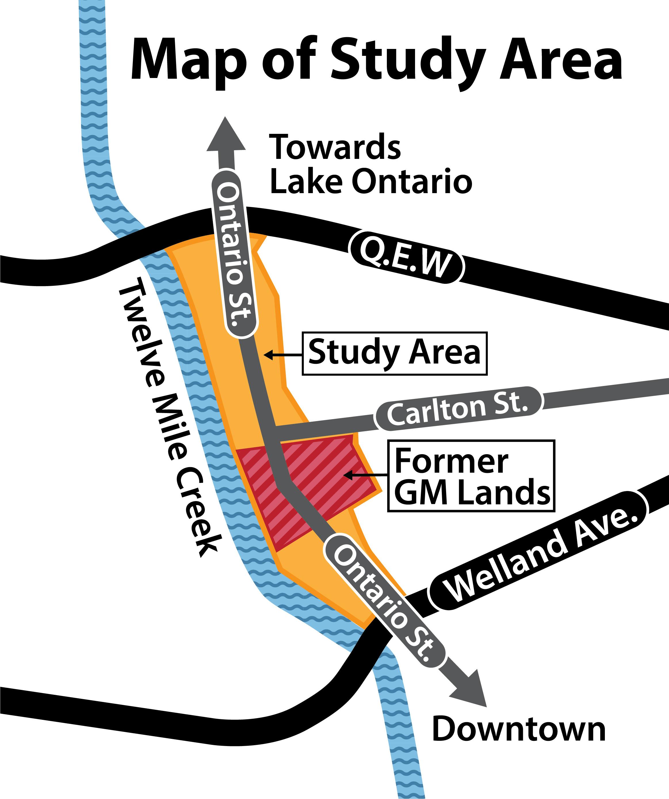
The City is launching a land-use study of the Ontario Street corridor from the QEW in the north to Welland Avenue in the south, leading into the downtown core. Watch our short video to learn more about the secondary plan study.
View our June 2023 Newsletter
Background
In May 2017, driven by the closure of the long-standing auto manufacturing use at 282 and 285 Ontario Street (referred to by many as the former GM lands), Council directed staff to evaluate alternative use permissions on those lands for future residential and mixed-use development. Most of the existing buildings on the properties have now been removed, and it is now a 20-hectare (50-acre) brownfield re-development site in the middle of the City.
Reflecting the historical use of the lands, the properties have long been designated employment in the City’s Official Plan. Changing use permissions requires an amendment to the Official Plan.
Based on a 2019 city-wide land needs assessment (LNA) City Council and the Region of Niagara approved an amendment to the City of St. Catharines’ Official Plan — Official Plan Amendment 26 (OPA 26) — to re-designate the lands at 282 and 285 Ontario Street in 2021.
Among other matters, OPA 26:
- re-designates the lands at 282 and 285 Ontario Street for future residential and mixed-use development opportunities
- requires that the subject lands are to be planned for future development through the creation and approval of a secondary plan
The LNA and OPA 26 represent the completion of the first two key planning components necessary to plan for future alternative uses on the subject lands. The next step is to undertake a secondary plan study to more precisely identify and evaluate land use opportunities, permissions, policies, and implementation strategies to guide future development; and the creation of a secondary plan for the subject lands.
Secondary Plan Study
On May 30, 2022, Council endorsed terms of reference to undertake the Ontario Street Corridor Secondary Plan Study. The study terms of reference, included in the Important Documents section on this page, identifies study area boundaries and key elements of the study, including context, planning framework, guiding principles and objectives, study management, public engagement, deliverables, and timeline. It is estimated that the study will take approximately two and a half years to complete.
Community Engagement
The historical use of the study lands has helped shape the economic, social, cultural and environmental fabric of the city, and the future use of the lands will also do so for generations to come. The study cannot just be looked at in isolation of the immediate area and must also be evaluated from community and city-wide perspectives. Neighbourhood and community-wide public engagement, consultation and input are critical components in the success of the study. The project team welcomes and encourages any and all public review and input into the study exercise and development of a recommended secondary plan.
A survey is currently open to seek public input following an in-person public open house that took place on Feb. 7. The display boards from the meeting can be viewed under the "Important Documents" tab on the right side of the page. Should you want to email the study team directly, here are the questions to consider.
The City will also continue to accept any general questions or feedback via EngageSTC, with the question-and-answer feature below, or contact one of the project team members listed on the right.
Neighbourhood Advisory Committee
The City is looking for interested members of the public to get involved in the Study by applying to become part of the Neighbourhood Advisory Committee.
The Neighbourhood Advisory Committee will be established to help guide, review and provide input into Study components. The composition of the Committee will be localized to the Study Area and area of influence, and will include the following:
- One to two landowner representatives from the Ontario Street north corridor, being the portion of the Study Area located north of Carlton Street.
- One to two landowner representatives from the Ontario Street south corridor, being the portion of the Study Area located south of Pleasant Avenue.
- Three to four residents of the area bounded by Twelve Mile Creek, the QEW, Geneva Street and Welland Avenue, including one representative from each of the Haig and Fitzgerald Neighbourhood Associations.
- Two St. Patrick's Ward 4 Councillors.
The role of the Committee is to speak and provide input on behalf of landowner and resident interests in the study area, and area of influence, and engage in the review and evaluation of study components. The Neighbourhood Advisory Committee is expected to meet with the Project Team on a quarterly or as-needed basis.
For more information on how to apply, please visit the project website: Ontario Street Corridor Secondary Plan Neighbourhood Advisory Committee - St. Catharines (stcatharines.ca)
-
June 2023 Newsletter
Share June 2023 Newsletter on Facebook Share June 2023 Newsletter on Twitter Share June 2023 Newsletter on Linkedin Email June 2023 Newsletter link
Stay in the know: View the June 2024 Newsletter