
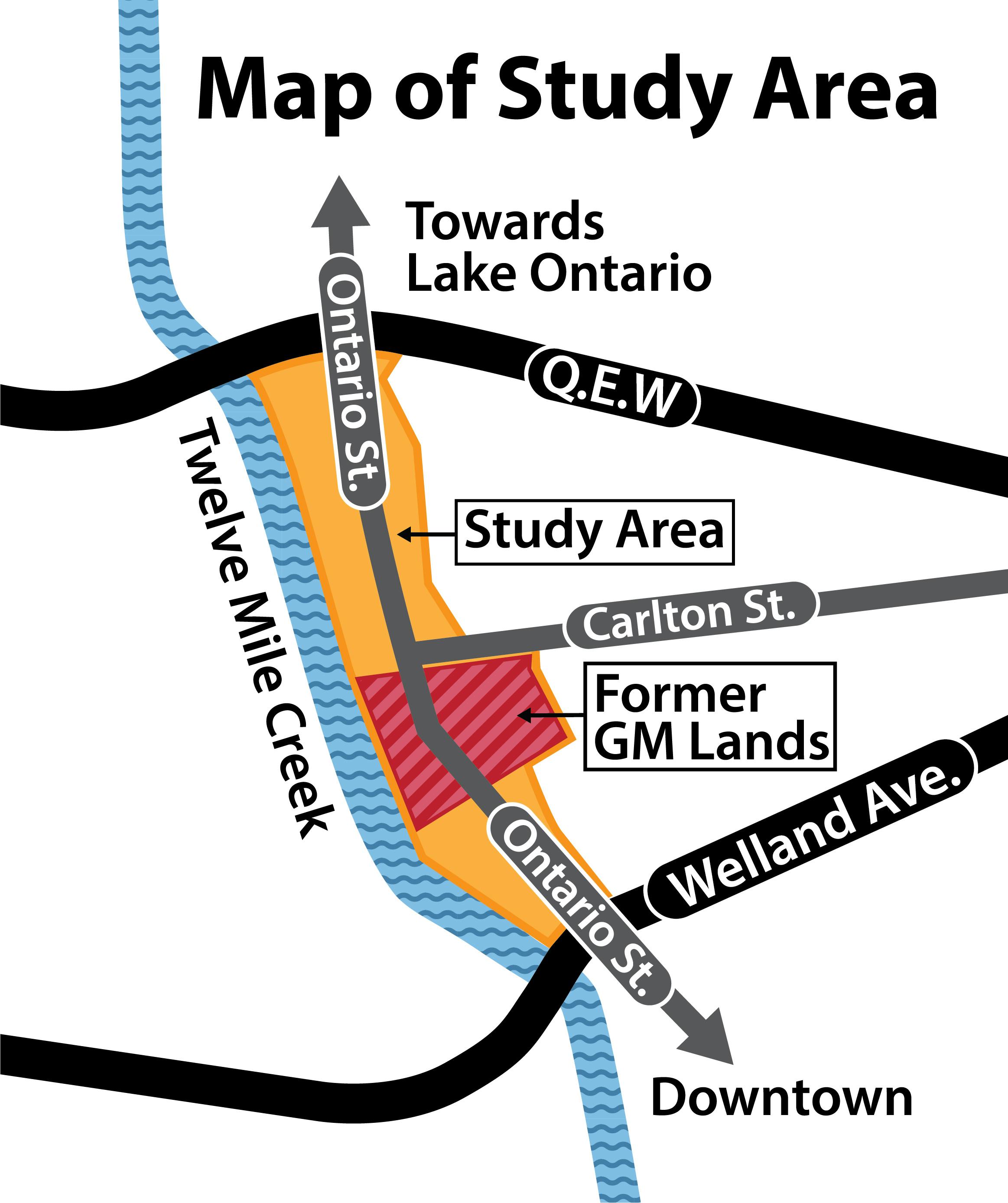
Ontario Street Corridor Secondary Plan Study
The City has launched a Secondary Plan study for the Ontario Street corridor, extending from the QEW in the north to Welland Avenue in the south, leading into the downtown core. A Secondary Plan is a detailed land use planning document that builds on the City’s Official Plan by providing more specific direction for how an area should grow and develop over time, including land uses, urban design, transportation, and infrastructure.
Status Updates
July 2026
An open house will be held on Wednesday, July 29 (Holiday Inn and Suites, Concord & Chardonnay Room, 327 Ontario Street, 5:30 p.m.), for review of draft Secondary Plan policies and schedules, developed through feedback from the April 14 and June 9 public open houses, the Neighbourhood Advisory Committee and the Technical Advisory Committee.
Residents, businesses, property owners and community members are invited to review the draft Secondary Plan, including the draft preferred concept, policy and technical evaluation report, in the "July 29 Open House Documents" widget to the right and share feedback. You can also click the following links:
- Preferred draft concept plan
- Draft Secondary Plan by-law and policy documents
- Technical Evaluation Report
- Public Notice
Written comments can be provided at the open house meeting, by using “Tell Us Your Thoughts” at the bottom of this page, or by emailing the project team at OntarioStreetStudy@stcatharines.ca. Please submit comments by Wednesday, August 5, 2026.
The Statutory Public Meeting for the Secondary Plan is expected to take place in September 2026.
June 2026
An open house was held on Tuesday, June 9, for a review of three concept plans for the Ontario Street Corridor, developed through feedback from the April 14, 2026 public open house, the Neighborhood Advisory Committee, and the Technical Advisory Committee.
Residents, businesses, property owners, and community members learned more about the study, reviewed the proposed concepts, shared feedback, and helped shape the long-term vision for the corridor.
The presentation showed at the open house can be viewed here and is also located in the June 2026 Concept Plans folder to the right.
A Community Visioning Summary Report highlights feedback received through April 2026 consultation sessions with residents, stakeholders, and advisory committees regarding the future of the 101-hectare Study Area in the City of St. Catharines. Concept plans developed based on the feedback received can be viewed here:
Input provided on the concept plans will help guide preliminary land-use concepts and the next phase of public consultation for the draft Secondary Plan.
April 2026
The City’s Planning and Building Services Department invited residents, businesses, property owners, and community members to attend a Public Open House on April 14, 2026 at the Holiday Inn and Suites to learn more about the study and participate in the Community Visioning process. This session provided an opportunity to review the background work completed to date and share ideas that will help shape the future direction of the Ontario Street Corridor. The presentation can be found in the Important Documents in the sidebar.
Community members were encouraged to attend, learn about the project, and share their perspectives as we begin shaping a vision for the Ontario Street Corridor.

March 2026
The Ontario Street Corridor Secondary Plan Background Report provides a comprehensive foundation to guide the future development of the Ontario Street Corridor Secondary Plan Area. The study examines growth trends, redevelopment opportunities, infrastructure needs, and the broader planning context within one of St. Catharines’ most significant urban corridors.
The findings of the Background Study will help inform the development of the Secondary Plan and support the creation of a long-term vision for the corridor that reflects community priorities and planning objectives. The Background Study Report is now available for public review and can be accessed here.
November 2025
After the project was paused in April 2024, Mayor Mat Siscoe issued a mayoral directive on Nov. 6, 2025, to reinstate the Ontario Street Corridor Secondary Plan study with the goal of bringing the proposed plan to Council for consideration by November 2026. The City has hired NPG Planning Solutions, and work has resumed on the project, with public engagement expected in April to commence the community visioning exercise. Watch this page for more details and subscribe for project updates using the “Stay Informed” widget.
May 2024
The Ontario Street Corridor Secondary Plan workplan has been delayed. This pause will allow Planning staff to temporarily re-direct and focus efforts on supporting the City’s Housing Accelerator Fund commitments and other strategic priorities, such as the Community Improvement Plan review, the Official Plan update, GO Station Major Transportation Station Area zoning implementation, Port Dalhousie Secondary Plan zoning implementation, and on-going Provincial conformity exercises.
The Ministry of the Environment, Conservation, and Parks (MECP) has provided their Certificate of Analysis for the December 2023 sampling undertaking which demonstrates that abatement actions to reduce and control discharge of PCB contaminated stormwater from the site has been successful. Staff will report back to Council in Q2 2025 with an update on project status and next steps.
Full memo available in the important documents section on this page.
June 2023
View our June 2023 Newsletter
Background
In May 2017, driven by the closure of the long-standing auto manufacturing use at 282 and 285 Ontario Street (referred to by many as the former GM lands), Council directed staff to evaluate alternative use permissions on those lands for future residential and mixed-use development. Most of the existing buildings on the properties have now been removed, and it is now a 20-hectare (50-acre) brownfield re-development site in the middle of the City.
Reflecting the historical use of the lands, the properties have long been designated employment in the City’s Official Plan. Changing use permissions requires an amendment to the Official Plan.
Based on a 2019 city-wide land needs assessment (LNA) City Council and the Region of Niagara approved an amendment to the City of St. Catharines’ Official Plan — Official Plan Amendment 26 (OPA 26) — to re-designate the lands at 282 and 285 Ontario Street in 2021.
Among other matters, OPA 26:
- re-designates the lands at 282 and 285 Ontario Street for future residential and mixed-use development opportunities
- requires that the subject lands are to be planned for future development through the creation and approval of a secondary plan
The LNA and OPA 26 represent the completion of the first two key planning components necessary to plan for future alternative uses on the subject lands. The next step is to undertake a secondary plan study to more precisely identify and evaluate land use opportunities, permissions, policies, and implementation strategies to guide future development; and the creation of a secondary plan for the subject lands.
Secondary Plan Study
On May 30, 2022, Council endorsed terms of reference to undertake the Ontario Street Corridor Secondary Plan Study. The study terms of reference, included in the Important Documents section on this page, identifies study area boundaries and key elements of the study, including context, planning framework, guiding principles and objectives, study management, public engagement, deliverables, and timeline. It is estimated that the study will take approximately two and a half years to complete.
Community Engagement
The historical use of the study lands has helped shape the economic, social, cultural and environmental fabric of the city, and the future use of the lands will also do so for generations to come. The study cannot just be looked at in isolation of the immediate area and must also be evaluated from community and city-wide perspectives. Neighbourhood and community-wide public engagement, consultation and input are critical components in the success of the study. The project team welcomes and encourages any and all public review and input into the study exercise and development of a recommended secondary plan.
A survey is currently open to seek public input following an in-person public open house that took place on Feb. 7. The display boards from the meeting can be viewed under the "Important Documents" tab on the right side of the page. Should you want to email the study team directly, here are the questions to consider.
The City will also continue to accept any general questions or feedback via EngageSTC, with the question-and-answer feature below, or contact one of the project team members listed on the right.
Neighbourhood Advisory Committee
The City is looking for interested members of the public to get involved in the Study by applying to become part of the Neighbourhood Advisory Committee.
The Neighbourhood Advisory Committee will be established to help guide, review and provide input into Study components. The composition of the Committee will be localized to the Study Area and area of influence, and will include the following:
- One to two landowner representatives from the Ontario Street north corridor, being the portion of the Study Area located north of Carlton Street.
- One to two landowner representatives from the Ontario Street south corridor, being the portion of the Study Area located south of Pleasant Avenue.
- Three to four residents of the area bounded by Twelve Mile Creek, the QEW, Geneva Street and Welland Avenue, including one representative from each of the Haig and Fitzgerald Neighbourhood Associations.
- Two St. Patrick's Ward 4 Councillors.
The role of the Committee is to speak and provide input on behalf of landowner and resident interests in the study area, and area of influence, and engage in the review and evaluation of study components. The Neighbourhood Advisory Committee is expected to meet with the Project Team on a quarterly or as-needed basis.
For more information on how to apply, please visit the project website: Ontario Street Corridor Secondary Plan Neighbourhood Advisory Committee - St. Catharines (stcatharines.ca)
Questions, comments and input
A link to the public notice can be found here.
The draft Secondary Plan concept, by-law and policies, along with the technical evaluation report, are now available for review and feedback. Find the documents at the following links:
- Preferred draft concept plan
- Draft Secondary Plan by-law and policy documents
- Technical Evaluation Report
Written comments can be provided at the open house meeting, by using this “Tell Us Your Thoughts” option, or by emailing the project team at OntarioStreetStudy@stcatharines.ca. Please submit comments by Wednesday, August 5, 2026. Feel free to also provide any comments and input on the study, or to ask the project team any questions or clarifications in the form below.

Thank you for your contribution!
Help us reach out to more people in the community
Share this with family and friends